The Mystery of Hy-Brasil: The Phantom Island That Vanished From Maps
FFacts On Tap Editorial Team Fact-checkedUpdated January 26, 20263 min read
Share
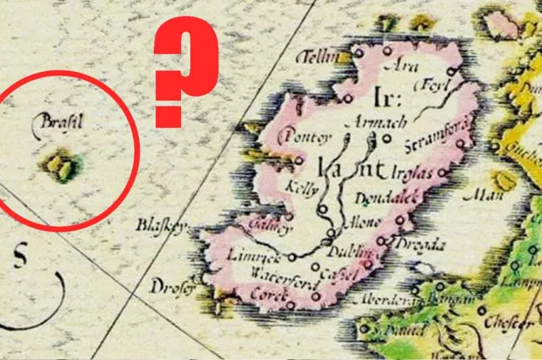
For more than five centuries, mapmakers drew a mysterious circular island off the west coast of Ireland called Hy-Brasil. Sailors reported glimpsing it through fog, cartographers copied it from chart to chart, and Irish legend said it appeared only once every seven years.
No one ever found it, yet it survived on official maps into the 19th century. Here's the real story behind one of history's most persistent phantom islands.
Hy-Brasil (also spelled Hy-Breasal or Brasil) is a legendary phantom island long said to lie in the Atlantic Ocean west of Ireland.
The name likely comes from the Irish "Ui Breasail," meaning "descendants of Breasal," a legendary Irish clan or king name — not a reference to modern Brazil.
In Irish folklore, the island was said to be shrouded in mist and visible to human eyes only once every seven years.
The earliest known map showing the island is a 1325 nautical chart by Genoese cartographer Angelino Dulcert (also known as Angelino Dalorto), who labeled it "Bracile."
The island appeared as a perfect red circle on the 1375 Catalan Atlas, a color scheme cartographers sometimes used to mark it as an unusual or unverified place.
Hy-Brasil also appeared on other historic maps and charts over the centuries, including versions attributed to the Ottoman admiral Piri Reis and the Flemish cartographer Abraham Ortelius.
Bristol merchants were searching for a mythical "Isle of Brasil" in the Atlantic in the 1480s and 1490s, around the same period John Cabot sailed west from England in 1497 in search of new lands.
According to a widely repeated legend, a Captain John Nisbet claimed in 1674 that his ship encountered dense fog off the Irish coast, and that Hy-Brasil emerged from the mist once the fog lifted.
The island was drawn as a circular landmass, sometimes shown with a river or strait running through its middle, on many of the maps that included it.
Some historians think Hy-Brasil began as a simple cartographic error or a misplaced, exaggerated sketch of a real landmass, such as Rockall or a shoal in the North Atlantic.
Other theories suggest sightings of the island were optical illusions, such as Fata Morgana mirages, which can make distant clouds or the horizon look like solid land.
Hy-Brasil was quietly dropped from British Admiralty charts in 1865, after cartographers concluded it was a geographical error that had simply been copied from map to map for centuries.
Even after it was removed from official charts, at least one reported sighting of Hy-Brasil was recorded in 1872, years after mapmakers had already abandoned it.
The Irish poet Thomas Moore referenced the legend in his 1810s song "O'Brazil, the Isle of the Blest," which romanticized the mythical island.
The legend of Hy-Brasil has been linked in popular culture to the broader myth of Atlantis, as both describe an advanced or blessed land lost to the sea.
Frequently asked questions
What is Hy-Brasil?
Hy-Brasil is a legendary phantom island that European maps placed in the Atlantic Ocean west of Ireland from the 14th century through the 19th century. It originates from Irish folklore and was never confirmed to exist.
Did Hy-Brasil ever exist?
There is no evidence it was a real island. Historians believe it was most likely a cartographic error, a misidentified real landmass, or a mirage-like optical illusion that got copied from map to map for generations.
When did Hy-Brasil disappear from maps?
It was removed from British Admiralty charts in 1865, once mapmakers concluded its existence could never be verified, though isolated reported sightings continued for a few years afterward.
Where does the name Hy-Brasil come from?
The name is thought to derive from the Irish "Ui Breasail," meaning descendants of Breasal, a legendary clan or king in Irish tradition. It is not related to the modern country of Brazil.
Which cartographer first drew Hy-Brasil?
The earliest known map showing the island is a 1325 nautical chart by the Genoese cartographer Angelino Dulcert (also known as Angelino Dalorto), who labeled it "Bracile."
We write every article to be genuinely fun — and genuinely true. Each fact is checked against reputable sources before it goes live. Spotted something off? Tell us and read our fact-check policy.